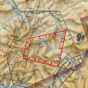
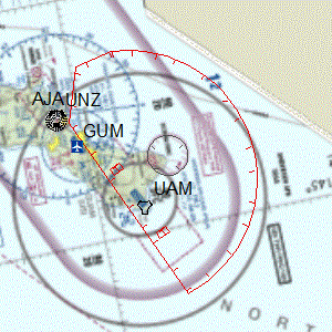
Scrapes TFRs from FAA site https://tfr.faa.gov/ and details for each TFR.
pip install tfr-scraper
tfr_list() #Returns the basic list of TFRs
#convert_degrees boolean is optinal defaults to true, converts coordinates from dms to dd ("26.02333333N", 097.12833333W") >>  (26.02333333, -97.12833333)
parse_tfr(notam_number, convert_degrees) #Parses a notam number in full format like (1/8339) and will return the details of the tfr.
get_list_and_parse_all(convert_degrees) #Downloads TFR list and parses all combines details with list and returns it.
save_detailed_all(filepath) #Does get_list_and_parse_all() and saves as a json, filepath is optional default is ./detailed_tfrs.json
save_detailed_all_cleaned(filepath) #Does get_list_and_parse_all() but also cleans some broken tfrs and saves as a json, filepath is optional default is ./detailed_tfrs.json- TFRs have many types wether it be just a circle or a polygon or a TFR can have multiple circles/polygons, this scraper will parse each.
- Below is an example of each and the type of shapes the parser will return in the shapes list for each when the details are parsed
"shapes": [
        {
          "type": "circle",
          "radius": 3,
          "lat": 28.4125,
          "lon": -81.57222222,
          "txtName": "Area",
          "valDistVerUpper": 3000,
          "valDistVerLower": 0,
          "uomDistVerUpper": "FT",
          "uomDistVerLower": "FT"
        }
]"shapes": [
{
"type": "poly",
"points": [
[
45.18833333,
-114.52583333
],
[
45.25972222,
-114.30388889
],
[
45.1,
-114.30388889
],
[
45.1,
-114.52583333
]
],
"txtName": "Hazard Area1",
"valDistVerUpper": 14500,
"valDistVerLower": 0,
"uomDistVerUpper": "FT",
"uomDistVerLower": "FT"
}
]- Any shape with a arc point.
"shapes": [
        {
          "type": "polyarc",
          "points": [
            [
              13.64166667,
              145.13527778
            ],
            [
              13.47666667,
              144.74694444
            ],
            [
              13.51194444,
              144.63722222
            ],
            [
              13.5875,
              144.61944444
            ]
          ],
          "arcRadius": 15.3,
          "arcPoint": [
            13.64166667,
            145.13527778
          ],
          "all_points": [
            [
              13.64166667,
              145.13527778
            ],
            [
              13.47666667,
              144.74694444
            ],
            [
              13.51194444,
              144.63722222
            ],
            [
              13.5875,
              144.61944444
            ],
            [
              13.60962359,
              144.62337227
            ],
            [
              13.63154738,
              144.62777753
            ],
            [
              13.65301205,
              144.63412072
            ],
            #Many more points
          ],
          "txtName": "Area A",
          "valDistVerUpper": 200,
          "valDistVerLower": 2600,
          "uomDistVerUpper": "FL",
          "uomDistVerLower": "FT"
        },
]- "points" represents only straight line points, can be used with "arcPoint" and "arcRadius" to create full shape
- "all_points" represents all points to create the entire polygon easily.
- Any shape, circle or poly that has parts that are excluded from TFR.
- Shape is returned as "all_points" only which represent one polygon excluding parts.
!

            "shapes": [
        {
          "type": "polyexclude",
          "all_points": [
            [
              40.16161713,
              -75.90540565
            ],
            [
              40.15632213,
              -75.92194558
            ],
            [
              40.13739634,
              -75.96895934
            ],
            [
              40.11538045,
              -76.01361666
            ],
            #Many more points
          ],
          "txtName": "Area A",
          "valDistVerUpper": 17999,
          "valDistVerLower": 0,
          "uomDistVerUpper": "FT",
          "uomDistVerLower": "FT"
        },
] "shapes": [
{
"type": "linebuffer",
"points": [
[
47.72194444,
-91.83277778
],
[
47.66277778,
-91.90222222
],
[
47.63,
-92.02638889
]
],
"valBuffer": "2",
"codeGeoFeatureType": "LINE",
"codeBufferBevel": "ROUNDED",
"all_points": [
[
47.63577472,
-92.07492876
],
#Many more points
],
"txtName": "Hazard Area1",
"valDistVerUpper": "5500",
"valDistVerLower": "0",
"uomDistVerUpper": "FT",
"uomDistVerLower": "FT",
"codeExclVerUpper": "INCLUDE",
"codeExclVerLower": "INCLUDE",
"isScheduledTfrArea": "FALSE"
}
]Single TFR object from list w/o details parsed
    {
    "Date": "08/11/2021",
    "NOTAM": "1/4928",
    "Facility": "ZSE",
    "State": "OR",
    "Type": "HAZARDS",
    "Description": "CANYONVILLE, OR, Wednesday, August 11, 2021 through Wednesday, September 01, 2021 UTC",
    "Zoom": "",
    },
A detailed object when combined with info from list
{
    "Date": "08/11/2021",
    "NOTAM": "1/4928",
    "Facility": "ZSE",
    "State": "OR",
    "Type": "HAZARDS",
    "Description": "CANYONVILLE, OR, Wednesday, August 11, 2021 through Wednesday, September 01, 2021 UTC",
    "Zoom": "",
    "details": {
      "txtDescrPurpose": "TO PROVIDE A SAFE ENVIRONMENT FOR FIRE FIGHTING AVIATION OPS",
      "txtLocalName": "1/4928",
      "dateEffective": "2021-08-11T16:30:00",
      "dateExpire": "2021-09-01T05:00:00",
      "codeTimeZone": "UTC",
      "codeExpirationTimeZone": "UTC",
      "shapes": [
        {
          "type": "poly",
          "points": [
            [
              42.97138889,
              -123.265
            ],
            [
              42.975,
              -123
            ],
            [
              42.86666667,
              -123
            ],
            [
              42.82361111,
              -123.08805556
            ],
            [
              42.75555556,
              -123.0875
            ],
            [
              42.75333333,
              -123.26694444
            ]
          ],
          "txtName": "Hazard Area1",
          "valDistVerUpper": 8500,
          "valDistVerLower": 0,
          "uomDistVerUpper": "FT",
          "uomDistVerLower": "FT"
        }
      ]
    }
}- html_table_parser.parser https://pypi.org/project/html-table-parser-python3/
- untangle https://pypi.org/project/untangle/
- pandas https://pypi.org/project/pandas/


