The CAMS weed app enhances our ability to manage weeds across a location by mapping the current status of the weed. The status is reset annually so that all locations are rechecked. Here's an example map:
The iNaturalist to CAMS synchroniser will update the CAMS weed app with new observations from iNaturalist. It will synchronise all observations with specific taxa (including descendents) from a particular place. To set up a new synchronisation email [email protected].
This guide assumes you already have an iNaturalist account and that the taxa and place you are entering are being synchronised.
We have created the Weed Management Aotearoa NZ iNaturalist project with observation fields that capture additional weed control data for the CAMS application.
The guide covers how to add and update observations to the Weed Management Aotearoa NZ iNaturalist project.
All observations (matching the specified taxa and places) will be synchronised, whether they are added to the Weed Management Aotearoa NZ or not.
However, adding the observation to the Weed Management Aotearoa NZ project and filling in relevant observation fields provides information that is useful for controlling the weed.
Before adding an observation to the Weed Management Aotearoa NZ project, you'll need to join the project.
Note that this can only be performed on the browser version, not on the mobile app.
Open the Join Weed Management Aotearoa NZ Project page, read the project page and select the Yes, I want to join button.
If you're not familiar with adding observations to iNaturalist see this guide.
When adding an observation, please check the location of the observation is accurate, and update it if necessary. This will help us to find the weed in future.
Note: the mobile app does not currently allow you to add other users' observations to projects. You'll need to use the browser version to add other users' observations.
When adding a new observation, click on the Add to project(s) option and select the Weed Management Aotearoa NZ project.
When editing one of your observations, click on the Edit (pencil) icon.
Note if someone else created the observation, you'll need to use the Browser version to add it to the Weed Management Aotearoa NZ project or update the observation fields.
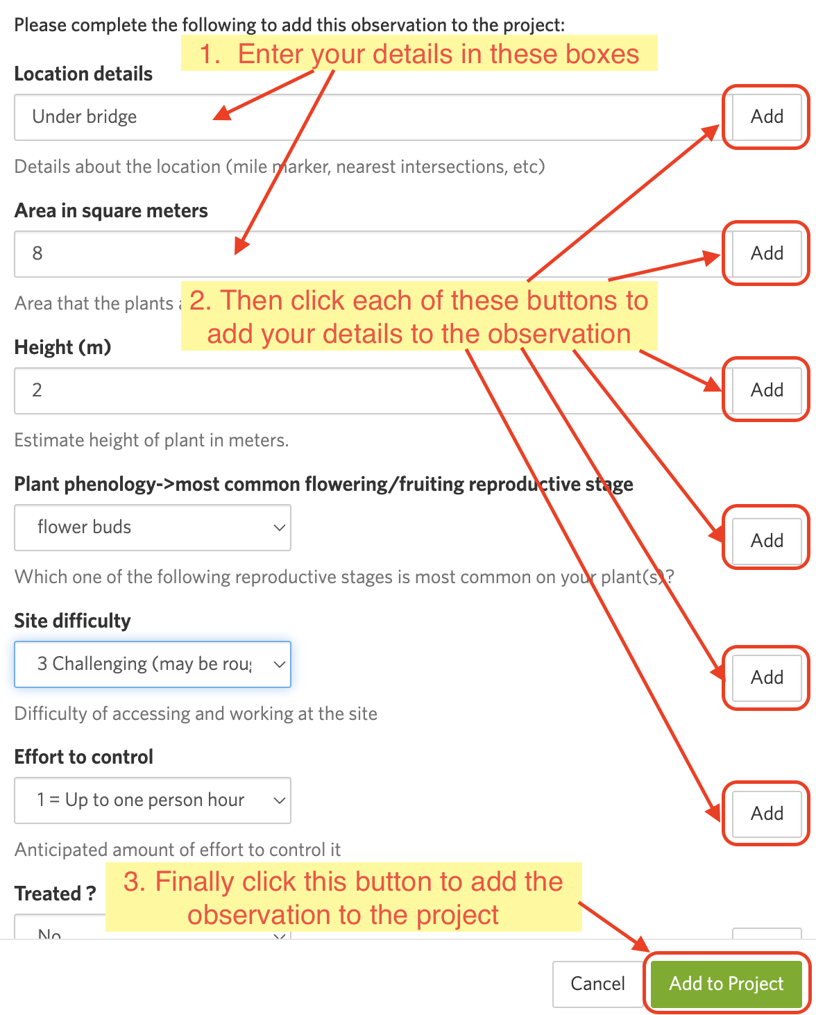
Fill out the fields, for example:
When adding a new observation, select the Projects option and add the observation to the Weed Management Aotearoa NZ project.
To update an existing observation, find (and expand if necessary) the Projects icon on the right of the screen, click the cog to the right of the Weed Management Aotearoa NZ project and select `Fill out project observation fields``
As you enter the details, you need to press the Add button next to each detail you wish to set. Failure to do this will mean that your details are not saved:
These fields help volunteers plan their work and control the weed:
| Field name | Description |
|---|---|
| Location details | A short description of the location that is shown on the CAMS map, eg. under bridge or downhill from gate. The geolocation should guide us to the approximate location |
| Area in square meters | The estimated size of the weed patch |
| Height (m) | The estimated height of the tallest part of the weed, in metres |
| Plant phenology->most common flowering/fruiting reproductive stage | The most common stage of plant growth |
| Site difficulty | The estimated difficulty of accessing the weed. Typically, levels 1-3 might be performed by the general public, level 4 by skilled workers, while level 5 typically requires professionals |
| Effort to control | The estimated time required to control the weed |
If you have done any control work on the weed, fill in these fields. This may be on the same day the weed was observed, or a later date. If the weed has previously been controlled, update the existing fields to reflect your weed control work.
| Field name | Description |
|---|---|
| Treated | Set to Yes if you have controlled the weed, or Partially if you've partially controlled it |
| Date controlled | Enter the date the control work was completed |
| How treated | Select the treatment you have used to control the weed |
| Treatment substance | If using herbicide, select the herbicide which you have used |
| Treatment details | Any additional details of how the weed was controlled |
| Follow-up (YYYY-MM) | Recommended date for a follow-up check or control work |
These fields allow you to update the status of an existing observation. This is typically used when you revisit a weed spot, but don't control it. You don't need to specify this if it is a new observation or if you have just controlled the weed.
If the status has already been set on the weed, you may need to override the status and/or the date of status update.
| Field name | Description |
|---|---|
| Status update | Whether the weed is currently alive or dead |
| Date of status update | Enter the date the status update was observed |
-
Why isn't my observation coming through to CAMS?
Firstly, observations are synchronised hourly. You might need to wait if it's less than an hour since you entered it in iNaturalist.
If using the mobile app, note that the observations, and updates, are stored locally and uploaded when your phone has a data connection. Sometimes this can get stuck.
Try clicking on the home button and then your observations to see if any are currently waiting or being uploaded.
Check also that your Settings have "Automatic Upload (Auto Sync)" ticked, or invoke a manual upload.


